
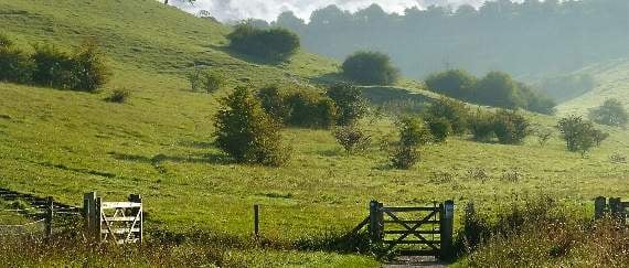
LANDSCAPE and the needs of local communities are central to the new South Downs National Park Local Plan, which has just been adopted by the national park authority.
It covers the entire national park for the next 14 years and sets out measures which include that any major new developments should seek to be carbon neutral, have better drainage schemes to reduce flood risk and limit water consumption.
The South Downs National Park covers an area between Winchester and Eastbourne that excludes cities and most major towns.
It stretches northwards between the A31 and A325 to just beyond Binsted but does not include Farnham, Haslemere, Alton, Four Marks, Alresford, Bordon, Liphook or Clanfield.



However, Petersfield is at the heart of the national park, which also includes Liss, Upper Farringdon, West Tisted, West Meon, Fernhurst, Milland, South Harting, Bucks Horn Oak and Alice Holt Forest.
The plan aims to ensure that growth is dispersed throughout the park rather than concentrated around large towns such as Petersfield, and to conserve internationally important landscapes such as Woolmer Forest.
Provision of land for housing and industry will be tightly controlled – a limit of 250 new homes per year across the park, of which half will have to be ‘affordable’ on sites where 11 or more houses are built, and just 10.3 hectares of land for employment.
As well as conserving clean water and air, dark night skies and tranquillity, the plan seeks to enhance green corridors to link habitats and support wildlife, and promote planting of new trees and hedges.
It replaces more than 1,000 overlapping policies that existed across the park with 92 new ones covering all aspects of planning.
Factors considered in its compilation included geography, geology, biodiversity, climate, heritage sites, neighbourhood plans and local economic needs.
It followed extensive public consultation and examination by the government’s Planning Inspectorate, which found it to be sound subject to a number of modifications.
Margaret Paren, who chairs the South Downs National Park Authority, said: “Our adopted local plan puts our nationally important landscapes first and ensures that they sit at the heart of every planning decision we make.
“While our first priority is to conserve and enhance the landscape, this local plan goes one step further by clearly outlining how we will nurture a living, thriving landscape that benefits local people.
“The local plan includes over 50 neighbourhood plans developed by South Downs communities which provide local development management policies and allocate land for development. We are grateful to all those who spent so much time assisting us.
“It also sets out the high standards that all proposed development must meet to protect nature and the vital ecosystem services it gives us, such as clean water, food and space to breathe.”
To see the full plan, visit southdowns.gov.uk/sdlocalplan.
Comments
This article has no comments yet. Be the first to leave a comment.