
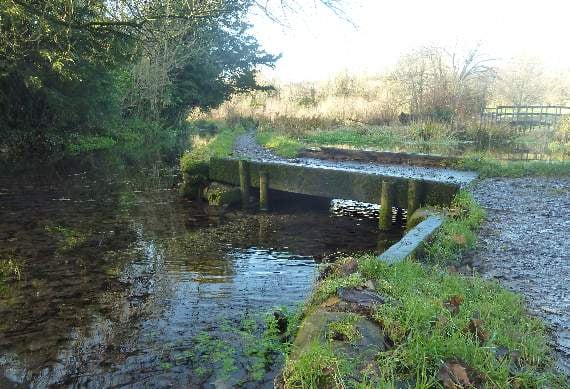
A NATURALIST has offered an explanation following the appearance of a picture in the Herald showing the dry bed of the River Wey.
The snap was taken as the river appears at the Basingstoke Road entrance to Flood Meadows in Alton, raising concern over diminishing water levels.
According to Dr June Chatfield, who received an OBE last year for services to conservation and natural history education, the answer is that the headwater of the northern Wey is a ‘winterbourne’.
Dr June said: “The study of hydrology is a complex but important one and subjected to variation from a variety of factors.



“The sources of the Wey in Alton are springs that rise from the chalk where water is stored. Groundwater originates as rainwater on the hills that surround Alton of which the bedrock is chalk.
“Where the chalk outcrops on the surface the rainwater soaks into the soil and by gravity as the supply increases it moves down the vertical and along the horizontal cracks.
“Its passage down continues until it meets impervious layers, which here are the lime-rich clays (marl) of lower strata and then it accumulates in the cracks of the bedrock and porous layers of the chalk.
“The top of this store is called the water table. Like most natural systems this fluctuates with season.
“Springs emerge from the ground at the junction of the porous and impervious layers of the chalk and they are in the valley floor (at Will Hall Farm) as the bedding planes of the twisted chalk slope or dip down to the valley.”
According to Dr June, the Will Hall springs are not the only groundwater sources.
There are, for example, active springs from the chalk at the back of the old watercress beds in Flood Meadows that are flowing slowly at the present time and flow through the Tanhouse Lane cress beds to join the river behind Lenten Street.
There is a lag in time between rain falling on the ground and its emergence from springs feeding rivers, the time varying with details of geology.
Dr June continued: “Until 2003 water was extracted from Weysprings pumping station and as the town grew in population and with increase in water use this supply became unsustainable and the river, instead of being dry for four months and flowing for eight was only flowing for about four.
“One year it was dry for 18 months, a phenomenon noted in other chalk streams with pumping stations, leading to a Government agency investigation in the 1990s.”
Alton’s water comes now from Lasham waterworks, from an aquifer deep in the chalk hills, and water levels are constantly monitored by the Environment Agency. Another source of water in the river is from surface run-off across the ground following gravity into the valley.
Dr June said: “Some of the chalk hills north of Alton have a capping of impervious clay-with-flints and this leads to surface run-off until the chalk outcrops and it can be soaked in.
“The increasing amount of hard surfaces of roads, pavements, front lawns being surfaced to make car parking, all adds to water entering road drains.
“Many of these, without any treatment and full of pollutants, empty into a watercourse as sewage treatment works are unable to cope with the volume of liquid waste.
“This can be seen in wet weather in the Wey by the railway bridge in Ashdell Road.”
While mitigating factors can cause either too much water, or not enough, Dr June is confident “come the New Year, the land springs (lavants) will rise in Will Hall and the river will flow again below the Basingstoke Road bridge.”
Comments
This article has no comments yet. Be the first to leave a comment.