
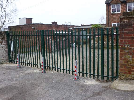
BATTLE lines have been drawn over Haslemere’s ‘war of the alley’in the run-up to a public inquiry to decide if a popular High Street shortcut can be made an official right of way.
Residents barred from using a popular cut-through to the shops from College Hill by a six-feet high steel fence, have to wait for a planning inspector to decide if it can be officially reopened as a public right of way.
Surrey County Council made a map modification order in November 2015 for a new public right of way – footpath 604, from Lloyds Bank to College Hill – but it went to appeal because an objection was received from the alley’s owners.
Case statements to the inquiry, which opens at 10am at Haslemere Museum, on Wednesday, November 30, have just been released and include the objection from the landowners, Hamish Robbie and Peter Warner, last December, which triggered the appeal.
-ambulance.jpeg?width=209&height=140&crop=209:145,smart&quality=75)

Lawyers acting for the landowners, objected there had been signs on the land for more than 20 years to say it was private property, and they should have been regarded as sufficient evidence to demonstrate it was not a public right of way.
But they had been “dismissed” by the county council in a finding described as “perverse”.
In its case statement to the inquiry, the council justified its finding by saying one sign was not visible to pedestrians and the other signs related to people using the former Lloyds Bank car park and “clearly” did not relate to people walking through.
Lawyers also objected “no accurate and proper notice” about the application for a map modification order had been served on the landowners, which is a mandatory requirement.
There was an outcry in February 2015, when a metal barrier was erected blocking the entrance to the alleyway from College Hill.
Residents were shocked to discover that although the shortcut had been used for many years, it had not been registered as a public right of way and so its obstruction was not illegal.
Keen to reclaim the path for the public, Haslemere Society made a formal application to Surrey County Council for a map modification order, supported by 64 sworn statements from users between 1968 to 2015 to show it had been in use for more than the requisite 20 years.
Users protested it was not only a long-established footpath but also a safer route to the High Street for pedestrians, because it avoided College Hill with its blind bend and inadequate pavements, but were informed safety issues were not relevant.
The landowners objected to Surrey CC?in December that its decision to approve the map modification was based on factors “entirely irrelevant to the question of whether or not a public footpath existed”, including a “balancing exercise between the merits of allowing pedestrians to use the footpath rather than travel by foot over College Hill”.
In its statement of case to the inquiry, Surrey noted safety issues “are not a relevant consideration” when deciding if public rights have been acquired, but also highlighted the fact concerns had been raised.
Surrey’s case statement includes a comment by the council’s highways team manager John Hilder, who said: “Using College Hill as the alternative route, pedestrians are likely to cross the road at the junction with the High Street to use a narrower footway on the western side, then cross again at the bend where this footway ends.
“Some may elect to walk in the carriageway on the eastern side of the road instead. So there is potential conflict with vehicles, when there is none using the ‘alleyway’.”
The council is calling six additional witnesses to support its case at the inquiry in addition to evidence by its senior countryside access officer Debbie Prismal.
Haslemere Society chairman Jane Stopford said: “The footpath had been in established use for generations and the society was dismayed the closure was done without any prior consultation or consideration, for those needing to use this safe pathway.
“They were pleased to look into the matter and provide the necessary expertise and information, to enable Surrey County Council to take up the case for the benefit of members, the Half Moon Residents’ Association and the wider community. The legal process to establish the status of the path has taken nearly two years to reach this stage.
“It is hoped the outcome of this enquiry will be published by the end of the year.”
Comments
This article has no comments yet. Be the first to leave a comment.