
THE closure of the Molson Coors brewery site for redevelopment has been seen by a group of residents as a “once-in-a-lifetime opportunity to create a legacy for the town” by constructing an attractive walk from Alton railway station along the River Wey as far as Brick Kiln Lane.
The brainchild of Alton and District Residents’ Associations (ADRA), the ‘Wey Walk’ is expected to open up opportunities for tourism as well as providing a traffic-free route for cyclists and walkers from the station, through the centre of town and out into the countryside beyond.
A working party was formed and a proposal drawn up and taken to Alton Town Council’s open spaces committee in May. The working party was joined by councillor Pam Jones and, after a number of meetings, a feasibility study was drawn up and presented to an open spaces meeting on January 4, when councillors endorsed the principle of the Wey Walk initiative and accepted it as a project run by a town council-appointed project manager.
With this in mind it was agreed to authorise officers to learn from previous experience, through discussions with Hampshire County Council and East Hampshire District Council, over how they developed, implemented and delivered the Shipwrights Way, including indications of the cost involved and officer time, to be discussed at the next meeting in order to determine a way forward for the Wey Walk project.


In a presentation to Alton Town Council, to explain the origin of the idea, ADRA chairman Louise Parker said that one of the issues at the top of their agenda was to look at ways of improving the vibrancy of the High Street and to make the most of the town’s tourist attractions.
Following news that Molson Coors was selling its Manor Park site, combined with the future development of land at Will Hall Farm, Alton and District Residents’ Associations members saw an opportunity to open up the river with the creation of an attractive and accessible route which they hoped would draw in tourists, by flagging up historical highlights such as the Allen Gallery and Curtis Museum, St Lawrence Church, the Civil War battle site and Fanny Adams’ grave to benefit the economic sustainability of the town.
The Wey Walk would, they believe, become an asset for residents by creating a “green lung” through the heart of Alton, which could be used by pedestrians, cyclists and wheelchair users for leisure and daily access, connecting residents from the Will Hall Farm end of town with the station area, and improving physical sustainability.
It is understood that, following advice and guidance from the Environment Agency, the installation of a walkway would result in enhanced scrutiny and the possible implementation of further precautions to prevent any future flooding, for example the installation of a sluice gate at New Odiham Road, ensuring there are enough culverts and that trash screens are provided at strategic intervals.
An ADRA spokesman said: “As a result, the whole course of the River Wey, from its source to Kings Pond, would have the appropriate measures in place to protect residents and businesses along the High Street and in properties adjacent to the river from flooding.”
In addition, since Alton has a strong brewing heritage, it was felt that by taking the route through the Coors site there would be the possibility of linking it in with an appropriate display to highlight the fact.
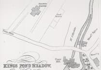
The proposed route would take the Wey Walk from the station down the steps to cross Paper Mill Lane to join the existing footpath that runs alongside the railway line to Lower Turk Street, or via Waterside Court to take the scenic route around Kings Pond. The path would then follow the river through the former brewery site, with opportunities to include an outdoor children’s play area between the path and the river, before crossing Drayman’s Way and continuing along Weyside Walk to the High Street.
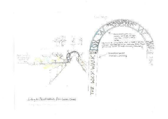
The suggestion is that the developer could install an archway at the Drayman’s Way crossing to form an attractive gateway entrance to the Manor Park site.
Having crossed the High Street the walkway would continue along Bakers Alley to rejoin the river at the Community Centre, continuing along Tanhouse Lane to Flood Meadows, following The Wey to the Lenten Street entrance where the proposal is for another archway entrance.
The path would eventually cross the New Odiham Road and follow the river through the lower field on the Will Hall Farm development to join up with Brick Kiln Lane, giving access into the countryside north-west of Alton toward Shalden.
Having walked the proposed route, ADRA has identified that the infrastructure is already in place for most of the route, while a substantial amount of the remaining stretches could be incorporated into the re-development of the Will Hall and Coors sites. While many of the signposts are already in position, the main work to be carried out, with the exception of general tidying and ground maintenance, would be to indicate the route itself.
One suggestion is to gradually extend the block paving in Bakers Alley along as much of the route as possible. In the short term, providing an outline for the route, marked for cyclists and pedestrians, could be easily done, and a more permanent route could be introduced over time.
The exception is linking the route with the railway station, where there is currently no step-free access, nor a safe route to cross Paper Mill Lane.
ADRA is now busy looking at ways of providing alternative routes where needed for cyclists and wheelchairs.
Comments
This article has no comments yet. Be the first to leave a comment.