

VOTERS in Farnham are being asked to have their say on the updated Farnham Neighbourhood Plan by voting in a special local referendum today (Thursday, March 12).
If the majority vote ’yes’ in favour of the plan, it will be used by Waverley Borough Council to help decide planning applications for the Farnham town area.
But how does the community-led plan propose to shape Farnham, and how has it evolved over the years?
Farnham’s Neighbourhood Plan, setting out a blueprint for development in the town built on the aspirations of local people, was adopted in July 2017 after a huge 88 per cent of the 11,391 people who voted in a May 2017 referendum backed the community-led document.


Infamously, it was sent back to the drawing board just weeks later, after Waverley Borough Council loaded the lion’s share of an upsurge in its housing target on the borough’s largest town – despite Farnham being the only town in Waverley with a ‘made’ neighbourhood plan.
However, two and a half years later, the town plan is back, bang up-to-date and stronger than ever – with sites earmarked for an additional 450 homes (on top of the 2,330 already catered for in the first plan), and boasting a far more comprehensive landscape study.
But it’s not all about housing – and the plan includes a grand total of 32 policies, which also strive to protect and enhance biodiversity, neighbourhood centres, public open spaces and sports provision.
All of which combined, it is hoped, will prevent speculative development and rogue appeal decisions in the town area – including Badshot Lea, Boundstone, Hale, Heath End, Rowledge, Shortheath, The Bourne, Upper Hale, Weybourne and Wrecclesham – once and for all.
But what has actually changed since 2017?
Over the past year, Farnham Town Council has carried out an extensive review with the community to shore up the plan and make sure it meets the basic conditions of a neighbourhood plan, as set out by the Government. As a result, the amended Neighbourhood Plan now:
* incorporates minor text updates and changes to reflect what has happened and permissions granted since the made plan was prepared and adopted,
* has a new 2032 end date, harmonised with the Waverley Local Plan for consistency, and
* allocates five new brownfield sites to meet the new housing target of an additional 450 homes.
These additional proposed ‘strategic’ housing sites are:
* The former Cobgates care home in Falkner Road, owned by Surrey County Council (approximate capacity: 40 dwellings).
* New student accommodation at the University for the Creative Arts, Falkner Road (252 student units or 217 net additional student units, equal to 72 homes).
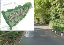
* Centrum Business Park, East Street, currently occupied by businesses including MOTEST and the Phyllis Tuckwell Hospice furniture shop (150 homes).
* Kimbers Lane, the current home of Waverley Training Services owned by Waverley Borough Council (20 dwellings).
* Comley Reclaim and Surrey Sawmills, Wrecclesham Hill (20 homes) – with the business currently looking to relocate.
Each site was promoted by land owners following a ‘call for sites’ by the town council in 2018, and more than 70 potential housing sites were put forward.
Assessed against the neighbourhood plan’s strict criteria, many were quickly ruled out however – with the town council then whittling down the remaining sites, focusing on locations that will minimise the use of the car and protect the spacious green setting of Farnham.
The five additional sites add to seven as-yet-undeveloped sites already identified in the made plan; including the former SSE depot in Lower Weybourne Lane (100 homes), Green Lane (105 homes) and Little Acres (35 homes – on top of the 94 homes already being built on the former nursery), Badshot Lea, the former PGL Garage in Guildford Road (ten homes), Colemans Yard, Wrecclesham Road (ten homes), Switchback Lane, Rowledge (ten homes), and the largest, Coxbridge Farm, off West Street (350 homes).
In all, the plan identifies land for 3,005 homes over the plan period (2013 to 2032) – 445 have already been built, and almost 1,000 more already have planning permission and are in the process of being built, or waiting to be.
Falling into this latter category are Brightwells (239 homes), The Woolmead (138 homes) and CALA Homes’ controversial Folly Heights development in Folly Hill (96 homes) after it was allowed on appeal in 2018.
Improvements to infrastructure to compensate for the influx of housing is largely outside of the town council’s control, and the plan’s remit.
However, the review has also identified two new sites of Suitable Alternative Natural Greenspace (SANG) at Tongham Road, Runfold and the Runfold South Quarry to offset the impact of the additional homes on the protected heathland surrounding Farnham.
In addition, more text has been added about the Waverley Abbey Conservation Area which was, says the town council, “inadvertently omitted” in the made plan.
And a map setting out Areas of High Landscape Value and Sensitivity has been amended based on a new Farnham Landscape Character Assessment, undertaken in July 2018.
For more information about the Neighbourhood Plan, visit www.farnham.gov.uk/shapefarnham
Comments
This article has no comments yet. Be the first to leave a comment.